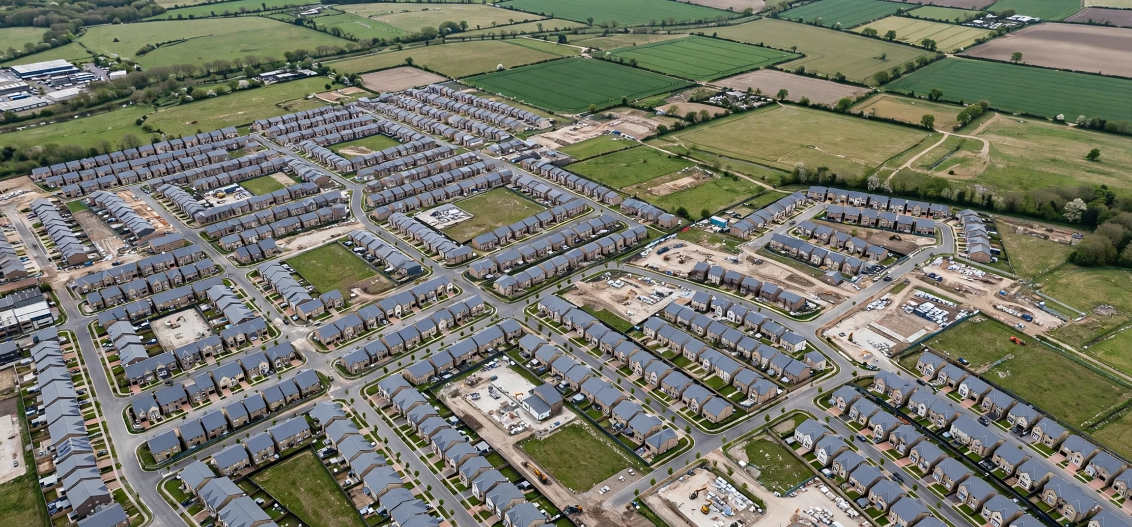
To define urban sprawl geography in clear terms, geographers describe it as the uncontrolled, low-density expansion of a city outward into surrounding rural land, farmland, and natural habitats. When students are asked to define urban sprawl geography in an exam or assignment, the expected answer goes beyond simply saying that a city is growing. It must explain the pattern of that growth: scattered housing estates, shopping centres, and business parks spreading along roads, with large gaps of unused land between developments, heavy reliance on private cars, and a falling population density as distance from the city centre increases. This pattern matters because it shapes housing costs, commuting times, air quality, public services, and the environment for decades after the first suburbs are built.
What It Means to Define Urban Sprawl Geography
To define urban sprawl geography properly, it helps to break the concept into three linked ideas: urban, sprawl, and geography. Urban refers to towns and cities and the built-up areas around them. Sprawl describes growth that is spread out, unplanned, or poorly planned, rather than compact and organised. Geography adds the spatial question: where is growth happening, why is it happening there, and what are the consequences for people and places? Put together, the term describes a spatial process in which a city expands over a larger area without a matching rise in population density. In other words, the city takes up more land per person, and the edge of the built-up area keeps moving outward year after year.
A useful classroom definition also distinguishes urban sprawl from ordinary urban growth. A city can grow taller, with apartments and offices filling gaps inside its existing boundary, and that is densification rather than sprawl. Sprawl is different because development leaps over open land, follows motorways and ring roads, and creates car-dependent neighbourhoods that are far from jobs, schools, and hospitals. To define urban sprawl geography in this fuller sense, therefore, geographers look at maps, population density figures, land-use change, and transport patterns together. A single new housing estate on the edge of town is not necessarily sprawl, but a repeating pattern of low-density, scattered, car-based development across a whole fringe zone certainly is.
Define Urban Sprawl Geography Through Its Main Causes
One of the clearest ways to define urban sprawl geography is to explain why it happens. Population growth is the most obvious driver: when more people move to a city for work or education, demand for housing rises, and developers often find it cheaper and easier to build on greenfield land at the edge than to redevelop brownfield sites inside the city. Rising incomes and the desire for larger homes with gardens also push households outward, especially when land and house prices are lower in the suburbs than in the centre. Improved roads and cheap car travel then make that outward move practical, because workers can live far from their jobs and still reach them by driving.
Government policy and planning decisions play a large part as well. Weak planning controls, generous road building, subsidised mortgages, and a lack of investment in public transport can all encourage scattered development. In some regions, local councils compete for new housing and business parks, approving fringe projects without considering the wider regional picture. Speculation adds another layer: landowners may hold plots near a city in the hope that planning permission will raise their value, creating the patchy, leapfrog pattern that is so typical of sprawl. To define urban sprawl geography fully, students should therefore link physical growth to these economic, social, and political causes rather than treating sprawl as a natural or inevitable process.
| Feature | Compact city growth | Urban sprawl |
|---|---|---|
| Population density | High and rising | Low and falling with distance from the centre |
| Land use | Mixed uses close together | Separated housing, shops, and workplaces |
| Transport | Walking, cycling, and public transport | Heavy dependence on private cars |
| Land take | Reuse of existing urban land | Large areas of farmland and habitat lost |
| Service costs | Lower per household | Higher per household for roads, pipes, and buses |
The Social, Economic, and Environmental Effects
The effects of urban sprawl reach far beyond longer commutes. Environmentally, sprawl consumes productive farmland, fragments wildlife habitats, and increases the area of sealed surfaces such as roads and car parks, which worsens surface flooding and reduces groundwater recharge. Because residents must drive for almost every trip, transport emissions rise, air pollution worsens, and cities become harder to serve with efficient bus or rail networks. Longer journeys also mean more time lost, more fuel burned, and higher household spending on cars, insurance, and maintenance, which can cancel out the savings from cheaper suburban housing.
Socially, sprawl can deepen inequality. People without cars, including teenagers, older residents, and lower-income households, may struggle to reach jobs, health care, and leisure facilities in scattered suburbs designed around driving. Meanwhile, inner-city areas can suffer from falling investment as shops and employers follow wealthier residents outward. Economically, councils face higher infrastructure costs: every new fringe estate needs roads, water pipes, sewers, street lighting, and school places, yet low-density areas generate relatively little tax revenue per hectare. That is why planners increasingly argue that the cheapest city in the long run is often a compact one, even if building inside existing boundaries looks more expensive at first.
There are, however, arguments in favour of suburban growth that a balanced answer should mention. Many families genuinely prefer detached homes, gardens, and quieter streets, and outward growth can relieve overcrowding and high rents in city centres. New fringe developments can also bring jobs, schools, and shops to areas that previously had few services. The geographical debate is therefore not simply growth against no growth. It is about the form growth takes: planned, connected, and serviced expansion near transport corridors is very different from scattered, car-dependent sprawl. If you want to define urban sprawl geography in an exam, showing that judgement, rather than only listing problems, will strengthen your answer considerably.
Examples, Case Studies, and How Cities Manage Sprawl
Classic examples help to define urban sprawl geography in a memorable way. Many North American cities expanded rapidly after the Second World War as car ownership rose, motorways were built, and suburbs spread over huge areas at very low densities. Los Angeles is often cited because its built-up area covers an enormous region with a strong car culture, while cities such as Atlanta and Houston show similar patterns of fringe growth, long commutes, and fragmented local government. In Europe, sprawl tends to be more contained by planning rules, yet cities from London to Madrid still show pressure on their green belts as housing demand pushes development outward along rail and road corridors.
Cities manage sprawl with a toolkit of planning measures. Green belts and urban growth boundaries draw a line beyond which building is restricted, protecting farmland and forcing developers to look inward. Brownfield-first policies encourage building on disused industrial land, while higher-density housing near stations supports public transport. Some cities introduce congestion charges, parking controls, and bus priority lanes to reduce car dependence, and others require new estates to include shops, schools, and cycle paths from the start. None of these tools works alone. The most successful strategies combine a firm edge to the city with attractive, well-serviced neighbourhoods inside it, so that living centrally becomes a genuine choice rather than a sacrifice.
For further reading on related definitions and city topics, see this guide to defining technical terms clearly, a look at city limits and urban addresses, and an overview of academic study and research topics. These internal guides show how a single concept can connect to wider questions about language, cities, and study skills, which is exactly the kind of linkage examiners reward when you define urban sprawl geography in a longer essay.
Students often ask how to define urban sprawl geography when a question mentions sustainability, and the answer is to connect the spatial pattern to resource use. A compact city shares walls, pipes, and bus routes between many households, while a sprawling city duplicates them across a wide area, which raises energy and water use per person. To define urban sprawl geography in a sustainability answer, therefore, mention land consumption, car dependence, and infrastructure cost together, and then note that well-planned suburbs near rail stations are a partial exception. That nuance shows that you understand sprawl as a pattern with degrees, not a label to apply to every new estate, and it is exactly the kind of balanced judgement that earns top marks in geography essays.
Frequently Asked Questions
What is the simplest way to define urban sprawl geography?
The simplest accurate definition is the low-density, unplanned or poorly planned outward expansion of a city into surrounding rural land, producing scattered, car-dependent development and falling population density away from the centre. Add one cause and one consequence, and you have a strong short answer that covers pattern, process, and impact in a single paragraph.
Is all suburban growth urban sprawl?
No. Planned suburbs built at reasonable densities, with shops, schools, parks, and public transport, are a normal part of city growth. Sprawl specifically means scattered, low-density, car-dependent expansion that consumes large amounts of land, separates homes from jobs and services, and is difficult and expensive to serve. The distinction is about pattern and connectivity, not simply about building outside the old city boundary.
Why do geographers study urban sprawl?
Geographers study sprawl because it links population change, housing markets, transport, planning policy, and environmental change in one visible landscape. By mapping where growth happens and measuring its costs, they can advise planners on how to house growing populations without destroying farmland, worsening pollution, or leaving car-less residents isolated. That practical purpose is why the topic appears so often in school and university geography courses.
Conclusion
To define urban sprawl geography with confidence, remember the core pattern: a city spreading outward at low density, in a scattered and car-dependent form, consuming rural land and raising the cost of services and travel. Causes include population growth, cheaper fringe land, rising car ownership, and planning choices, while consequences range from habitat loss and emissions to social exclusion and expensive infrastructure. The best responses combine firm planning boundaries with attractive compact development inside the city. Master that chain of cause, pattern, and consequence, and you can define urban sprawl geography clearly in any exam, essay, or classroom discussion.